Resilience Program
Resilience Program
2026 Program Update
The Arizona Department of Transportation is developing a Resilience Improvement Plan (RIP) to enhance the administration, planning, programming, design, construction, maintenance, and operations of its extensive roadway network. The plan will move decision making to a formal quantitative, probabilistic, and data-driven approach to identify highway assets vulnerable to natural hazard, extreme weather, climate trends, thereby guiding ADOT's investment decisions through a resilience lens utilizing ADOT's years of foundational work, including its existing data, processes, and tools.
This effort began with the completion of a Resilience Improvement Plan Primer.
This effort continued with the development of RIP 1.0, which will act as ADOT's official Statewide Resilience Plan. RIP 1.0 builds on the foundation set by the Resilience Improvement Plan Primer.
The working papers inclusive in RIP 1.0 are as follows:
- Working Paper 1.2 - Existing Documentation, Data, and Recommendations Review
- Working Paper 1.3 - Strengthened Policy Section & Integration of Emergency Preparedness & Response
- Working Paper 1.4 - Risk Assessment
- Working Paper 1.5 - Project Prioritization
ADOT will continue to expand its resilience program efforts in the upcoming RIP 2.0, which will position ADOT to be aligned with innovative resilience best practices. The RIP 2.0 approach will include the following tasks:
- Moving from screening to probabilistic modeling.
- Qualifying hazard under future conditions.
- Modeling asset vulnerability and deterioration explicitly.
- Translating risk into comparable decision metrics.
- Application into project prioritization and programming.
2023 Program Update
- 2020 Program Activity - Asset Management - Infrastructure Resilience Final Report
Transportation infrastructure is a complex system of assets required to deliver multiple services and functions. As fiscal constraints for the development and rehabilitation of roadways remain, and repeated retrofitting to address the impacts of extreme weather and climate risks continues to be cost prohibitive, new and novel approaches to long-term planning, asset management, project development, engineering design, and lifecycle planning are paramount.
The management of the roadway system has now evolved from a decentralized, project-based focus to one that encompasses enterprise-wide endeavors: administration, asset management, technology adoption, planning, design, construction, operations and maintenance. In addition, the expansion of risk analysis for extreme weather management and climate adaptation has complicated the long-term delivery of these complex transportation systems. ADOT seeks to combine risk, science, technology, and engineering to improve the understanding of weather-related risks to its transportation system, in order to accomplish its mission “Connecting Arizona. Everyone. Every Day. Everywhere” and its vision to become the most reliable transportation system in the nation.
ADOT has developed a programmatic approach to addressing all aspects of weather and natural hazards – including extreme weather and future measurable climate trends through a formal Resilience Program and three Transportation Research Board (TRB) papers and presentations;
2015 TRB Annual Meeting, Session 197: Mainstreaming Climate Change and Extreme Weather Resilience into Transportation, ADOT introduced the challenge ahead for public entities to coordinate a host of known and unknown extreme weather and climate trends issues. That challenge is:
Continue considering the balance between predictable asset deterioration curves, the sudden and unpredictable nature of extreme weather events and long-term climate trends, new models for risk assessment and lifecycle cost analysis, and appropriate adaptation strategies.
This multiple part challenge required a new end-to-end engineering approach to incorporate such current and future risks. At the 2016 Annual Meeting ADOT submitted a paper representing the core of that new approach – a Resilience Program and an ADOT/United States Geological Survey (USGS) Partnership. That paper was graciously recognized as a best paper by the TRB Special Task Force on Climate Change and Energy.
Continuing that forward progress – the 2017 TRB paper presented the remaining parts needed to develop a new end-to-end engineering-based asset adaption process – a structured sequence to incorporate extreme weather and climate adaptation into the design engineering process. The paper benefited from preeminent researchers in the two integral, and practice ready, remaining parts – probabilistic modeling for engineering design and infrastructure system design lifecycle outcomes for extreme weather and climate considerations in a transportation engineering setting.
All these efforts reflect eight years of ADOT extreme weather management, climate adaptation, and resiliency work. The current Resilience Program scope and goals are driven by the aforementioned engineering process that also encompasses a risk-based, asset management, and life cycle planning approach. The program continues to identify the stressors that pose the highest threats to ADOT’s transportation system by addressing the following:
- Intense Precipitation
- System Flooding
- Wildfires
- Wildfire-Induced Floods
- Drought-Related Dust Storms
- Rockfall Incidents
- Slope Failures
- Increased Surface Temperatures
Where is ADOT Now?
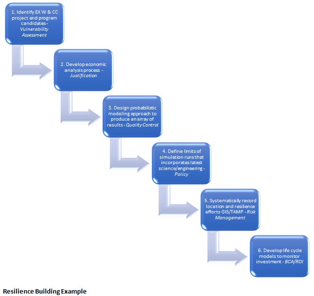
Goal: Develop a new end-to-end engineering-based asset adaption process – a structured sequence to incorporate extreme weather and climate adaptation into the design engineering process.
ADOT Climate Engineering Assessment for Transportation Assets (CEA-TA) – A Structured Sequence
This process was developed during 2017 to 2018; pilot projects are underway to implement this sequenced process. The process now in use at ADOT allows engineering and technical areas to manage risk, develop long term asset management strategies, and incorporate into project level assessments; it specifically also allows for the management of assets (bridges, culverts, pavement, and roadside vegetation/stabilization) in relation to the extreme weather-climate risk of intense precipitation, system flooding, wildfires, wildfire-induced floods, drought-related dust storms, rockfall incidents, slope failures, and measurable climate trends (especially as it relates to precipitation and direct effects of increased surface temperatures) by regions or specific segments emphasized as critical. The structured sequence is best used when proxy indicators and/or root cause analysis are facilitated through Steps 1,2,5,6 have been executed and due to the asset class or single asset priority is in need of deeper engineering informed decision-making effort – therefore rendering a probabilistic modeling exercise (Steps 3 and 4) viable. (See Exhibit 8 below)
Exhibit: ADOT Climate Engineering Assessment for Transportation Assets (CEA-TA) – Incorporating Probabilistic Analysis into Extreme Weather and Climate Change Design Engineering.
[1] Root cause analysis refers to the evaluation of a system or asset’s lifecycle stages to determine the factors directly contributing to the problem/impact to the roadway. (Examples could include under-capacity drainage systems and/or need for increased maintenance – cleaning of drainage structures to address system flooding).
191 AP 436 H867601C, milepost 436 to Chinle project
This project was a pavement preservation project, with the main purpose to rehabilitate the existing pavement to extend its life and to improve the ride and safety of the roadway. At issue was the presence of 50-year old culverts that had reached end of life. The main objective was to conduct basic economic analysis that included the following basic parameters:
- Protect the new $5.2M roadway investment
- Address severe erosional and drainage issues that has led to a 25%-100% degradation at sixty-one (61) of the eighty-six (86) corrugated metal pipe (CMP) drainage structures
- Address drainage excavation, barrow and slope stabilization issues at those structures
- Address severely compromised stormwater management capabilities along this segment of SR 191
- Comply with and proactively address expected regulatory actions on stormwater management, FHWA Order 5520, Presidential Executive Order on Federal Flood Risk Management, and MAP-21 asset preservation performance requirements
- Upgrade ADOT’s application of risk-based assessment modeling at the asset class, project development, and localized hydrological event level
- Further ensure use of SR 191 in the remote far northwest of Arizona and a main Apache County connector between SR 264 and US 160 in the advent of an extreme weather event
After ADOT’s assessment of the structures, it was determined that extensive stormwater management benefits could be developed to further protect the investment of the project and comply with ADOT Stormwater Environmental Protection Agency and Arizona Department of Environmental Quality needs. The subsequent District assessment allowed for an engineering design plan station by station scope of work approach, which was submitted to Statewide Project Management and Roadway for implementation into the project limits plan set. The Environmental Planning Group conducted an ADOT Future Inventory System cross check of each of the eighty-six (86) structures to ensure the quality of the asset information and to ascertain the appropriate approach for waters of the U.S. permitting requirements.
This assessment led to an expanded scope of work, extended the roadway’s lifecycle, addressed regulatory requirements, lowered the probability of water getting under the embankment, pipe washout, and overtopping of the road due to buried or lower capacity, end of life drainage structure capabilities.
The following exhibits show the pre-and post-construction conditions of this project. This is an example of a $275,000 resilience building outlay that improved asset management, the roadway asset lifecycle, and created a more resilient road segment by measurably improving the ability for the drainage facilities to convey up to the 50-year event.
Chinle Drainage Project Assessment (2015)


