The Arizona Department of Transportation in partnership with Pinal County began the Battaglia Drive shoulder widening project between Henness and Overfield roads in June 2026. The purpose of the project is to construct a wider shoulder to help improve mobility along the corridor.
The Arizona Department of Transportation in partnership with the City of Casa Grande began a project in January 2026 to install a traffic signal at Centennial Boulevard and Pinal Avenue (State Route 387). Additional improvements will feature: curb ramps for pedestrian accessibility, a right-turn lane for southbound to westbound traffic, and other related items.
The Arizona Department of Transportation is conducting a traffic circulation study along Interstate 10 within Pima County. The objective of this study will determine the best and most cost-effective options for reducing traffic delays and congestion on Interstate 10 at Marana Road and Cortaro Road including all intersections in between.
The Arizona Department of Transportation and the Federal Highway Administration (FHWA) completed a project to improve safety and traffic flow on I-10 between the Ina Road and Ruthrauff Road interchanges in Tucson.
The Arizona Department of Transportation began the Interstate 10: Amole Interchange and Union Pacific Railroad Bridge Rehabilitation Project in November 2025, and construction is expected to continue until fall 2026.
The Arizona Department of Transportation is working to improve the Interstate 19 and Irvington Road interchange. The project will reconstruct the interchange to increase capacity and enhance safety by widening Irvington Road to three lanes in each direction and adding lanes to the I-19 on-ramps. The project is scheduled to begin construction in the summer of 2026.
The Arizona Department of Transportation began the Interstate 19: Western Avenue/Target Range Road Bridges rehabilitation project in February 2026. The purpose of the project is to maintain the structural integrity of the two existing bridges.
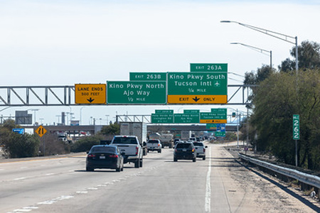
The Arizona Department of Transportation is making improvements to Interstate 10 in Tucson. The Interstate 10: Kino to Country Club project is the first project to come out of the Interstate 10 and State Route 210 Transportation Design Concept Report (DCR) that was completed in 2020.
The Arizona Department of Transportation began a project in April 2025 to install and connect Intelligent Transportation System (ITS) devices to the high-speed fiber optics cable along Interstate 19 starting at milepost 2, near the Nogales Port of Entry to just south of Interstate 10
The Arizona Department of Transportation is working on a pavement rehabilitation project, on State Route 289 from milepost 0 (Ruby Road) to milepost 11 (Peña Blanca Lake parking lot) approximately seven miles north of the city of Nogales. Construction began in October 2025.


